Phoenix, Maricopa County, Arizona
This 523,619-square-foot, 34-story tower is Arizona's tallest residential structure. The building's design was inspired by Jennifer J.L. Jones' painting named "Five Elements."
Cleator, Yavapai County, Arizona
Created by Presidential proclamation on January 11, 2000, the 71,100 acre (288 km�) monument has over 450 distinct Native American structures, some of large pueblos containing more than 100 rooms each.
Phoenix, Maricopa County, Arizona, 85007
The design of the Capitol is optimized for the desert climate of Arizona. The thick masonry walls insulate the interior, while skylights and round "bullseye" clerestory windows let heat out.
Chinle, Apache County, Arizona
The monument covers 131 square miles (339 km2) and encompasses the floors and rims of the three major canyons: de Chelly, del Muerto, and Monument. These canyons were cut by streams with headwaters in the Chuska mountains.
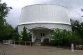
Flagstaff, Coconino County, Arizona, 86001
Lowell Observatory is among the oldest observatories in the United States. It was founded in 1894 by astronomer Percival Lowell, and the Observatory's original 24-inch (0.61 m) Alvan Clark Telescope is still in use today for public education.
Arizona
The site was formerly known as the Canyon Diablo Crater, and scientists generally refer to it as Barringer Crater in honor of Daniel Barringer who was first to suggest that it was produced by meteorite impact.
Arizona
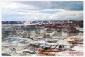
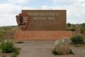
The Petrified Forest features one of the world's largest and most colorful concentrations of petrified wood. The park covers 218,533 acres (341.5 sq mi / 885 km�).
Coconino County, Arizona
SP Crater is a cinder cone volcano. The base of the cone is 3,900 feet (1,200 m) across and 820 feet (250 m) tall. It has a lava flow that extends for four miles to the north.
Arizona
The park was established as Saguaro National Monument on March 1, 1933 and changed to a national park on October 14, 1994. The total area of Saguaro National Park in 2002 was 143 square miles (370 km�) of which 111 square miles (289 km�) is wilderness.
Coconino County, Arizona
Sunset Crater was named for its brilliantly colored scoria deposits mantling the cone. Having erupted sometime between 1080 and 1150 AD, it is the youngest of the more than 550 vents of the vast San Francisco volcanic field.
Tucson, Pima County, Arizona, 85701
The UniSource Energy Tower is the tallest building in Tucson and 13th tallest in Arizona. The building is 330 feet tall (100.584 meters) and 25 floors. It was designed by Fentress Bradburn Architects Ltd. in 1988.
Glendale, Maricopa County, Arizona, 85305
University of Phoenix Stadium is a multipurpose stadium, Its primary tenants are the Arizona Cardinals of the NFL and the Tostitos Fiesta Bowl. It is the location for Superbowl XLII.